THINGS TO DO > GREAT OUTDOORS
Waterfalls
There are over 100 waterfalls in the White Mountains, and more in the nearby Lakes Region. Some, like Silver and Flume Cascades are easily seen from the road, while others require a hike.
The waterfalls mentioned below were chosen for their beauty and accessibility.
Whichever waterfalls you choose to explore, please remember to wear sturdy, flat, rubber-soled walking shoes and take care during your explorations. Rocks and water make for slippery, and sometimes even dangerous going. Swim only where allowed and never drink the water.
Help keep these special places beautiful by taking out everything you brought in, especially if you picnic. Always stay on marked trails and respect private property so that we can all continue to enjoy these remarkable falls for many years to come.
Arethusa Falls, Bemis Brook Falls
Livermore, NH. 1 mile path south of Willey House site off Rt. 302 in Crawford Notch.
Height: 176′. Water Source: Bemis Brook
Arethusa Falls is claimed to be New Hampshire’s tallest waterfall as all 160′ of its falls are in one continuous drop! Located on Route 302 access to this incredible force of nature can be made by by hiking the 1.5 mile moderately difficult trail. The falls were first discovered by Edward Tuckerman in 1875 and he chose the name “Arethusa” which in Greek mythology, was the name of a nymph that turned into a fountain.
Bridal Veil Falls
Franconia, NH. Coppermine Trail off Route 116 near Easton.
Height: 80′. Water Source: Coppermine Brook
This popular 80-ft. waterfall is accessed via the Coppermine Trail. Expect a moderate, consistent grade, frequent brook views, and a little over 5 roundtrip miles ready for adventuring. The stunner of this trail is its namesake: Bridal Veil Falls.
The Basin
Lincoln, NH at Franconia Notch
Water Source: Pemigewasset River
Directions: Rte 93 to The Basin parking lot. This large pothole in the Pemigewasset River, 30 feet in diameter and 15 feet deep, had its beginning some 25,000 years ago as the Ice Age came to a close. Water flowing from the melting glacier that filled Franconia Notch eroded the solid granite bedrock. During the thousands of years that followed sand and stones were whirled around by the force of the river causing a boring action that left the sidewalls smooth. The rock formation seen in the stream bed at the outlet has been known for generations as “The Old Man’s Foot”. The Basin can be accessed from the northbound and southbound directions. There are picnic tables and walking paths, as well as hiking trails.
Falling Waters
Lincoln, NH at Franconia Notch. Rte 93 to the Lafayette Campgound parking lot heading south, or the trailhead parking lot heading north.
Water Source: Falls Brook
5 falls can be seen along this trail which begins opposite Lafayette Campground. The Falling Waters Trail is a popular trail to the summit of Little Haystack Mountain. Stairs Falls is the first waterfall seen on this trip. A few hundred feet above Stairs Falls is Swiftwater Falls; a 60-foot tall mix of cascades and small plunges. The last waterfall, and by far the main attraction of this trail, is 80-foot Cloudland Falls, a picturesque fan-type horsetail. Like the other two waterfalls, this waterfall can be seen from the trail, but the best views are afforded by sidestepping off the main trail and getting closer to the falls. Upon reaching the summit of Little Haystack Mountain (4840′), one can return to the parking lot via the Falling Waters Trail or continue along the Franconia Ridge Trail to Mount Lincoln (5089′) and to Mount Lafayette (5260′). From Mt. Lafayette, one can descend to the parking lot via the Old Bridle Path. 6-12 miles round trip.
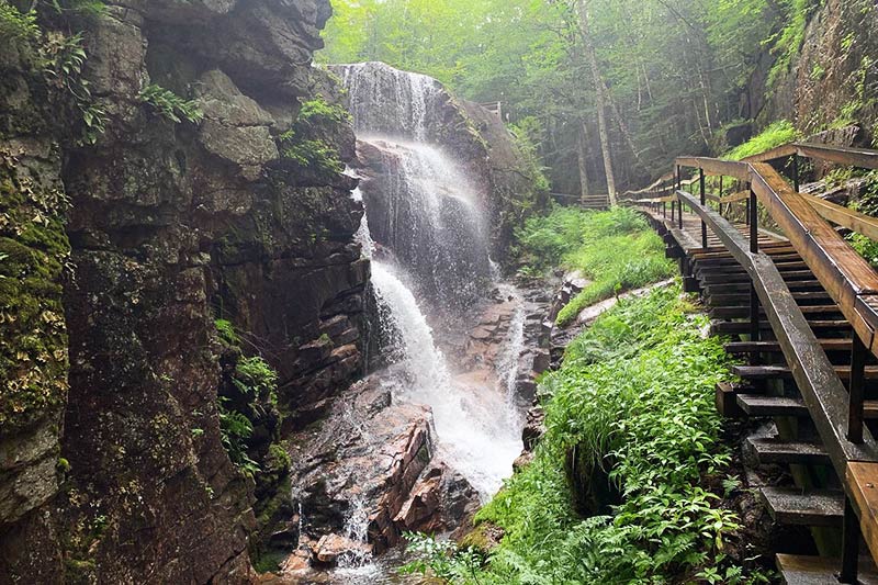
The Flume Gorge
Franconia Notch State Park. The walk through this 800 ft. natural chasm takes you past waterfalls and scenic pools. The Flume is a natural gorge extending 800 feet at the base of Mount Liberty. The walls of Conway granite rise to a height of 70 to 90 feet and are 12 to 20 feet apart. The Flume Trail is a 2-mile loop starting at the check-in booths located in front of the Flume Building. The Short Trail/Rim Path is closed and the only option is to complete the full 2 mile loop. The entire loop takes approximately 1.5 hours and finishes at the Flume Building. The walk includes uphill walking and lots of stairs. The boardwalk allows you to look closely at the growth of flowers, ferns and mosses found here.