THINGS TO DO > GREAT OUTDOORS
Itineraries
The Franconia Region is unsurpassed as the threshold to scenic drives and day trips in Northern New Hampshire.
Situated in the Western valley from the top of Franconia Notch State Park, all the scenic routes and roads form loops in every direction. It is no coincidence that this location is just East of the signature geographical jutting chin as New Hampshire narrows her shape from this point upward to Canada along the Connecticut River that defines the state line with her sister state, Vermont.
After all, it was here that natural glaciation formed the Old Man of the Mountain that jutted out over Franconia Notch symbolizing the ruggedness of the people that settled here. Over 400 years ago, these scenic loops were paths of necessity and survival for early explorers and settlers who followed the surreptitious trails of native American Indians – the first people to find and protect the traverses around and through the great expanse of forests, mountains and cliffs.
Follow any loop and you’ll be back in the Franconia Region at your favorite destination before dinner.
Route 117 Franconia to Sugar Hill Loop - And beyond
A New Hampshire Scenic and Cultural Byway where the views of the mountains from Sugar Hill and Sunset Hill Road, are the Postcard Views of the White Mountains – Not to be missed! Get a local area map at the Welcome Center on Main Street in. Pick up a New Hampshire map or a map of the White Mountain Attractions while you are there to show you the back roads and clearly marked routes to the best New England scenic tour on the western side of the White Mountains, through villages, rivers, waterfalls and working covered bridges that still connect both sides of entire villages.
From Route 117 at the end of Sugar Hill village, turn left onto South Road which leads onto Lafayette Road. Turn left onto Ridge Road, a dirt road passing the historical Frost Place. At the end, turn right onto Route 116 and follow it to the intersection of Route 112. Pick up Route 116 again on your right which will take you over Benton, winding through hills and valleys coming down to North Haverhill. Turn right on Route 10 to Woodsville, pick up Route 302 to the intersection with Route 112 which follows the Wild Ammonoosuc River past covered bridges over “ole swimming holes” and back to Route 116 back to Franconia; or stay on 112 all the way through Kinsman Notch, past Lost River and Ruggles Mines to North Woodstock. Turn left to Route 3 which will bring you North to Clark’s Bears, past the Indian Head rock formation and Resort and back through Franconia Notch State Parkway.
Exit 32 from I-93 North or South leads to Lincoln, and the Eastern side of Route 112 that is called The Kancamagus Pass, or Scenic Byway.
The “Kanc” climbs to nearly 3000 feet and is one of only two such roads in Northern New England. Allow an hour for this 35 mile trip, as the highway winds and turns through the valley below the mountain ranges, making the going slow.
There are many wild animals like moose and deer as well as smaller mammals to see. Moose collisions are common and dangerous- remember to brake for moose!
There are hundreds of miles of trails accessible from the highway with numerous trailheads as well as US Forest Service campgrounds that are great for introducing kids to the wonders of the Whites.
Boulder Loop is a National Recreation Trail along the Kanc that features a guided tour of White Mountain ecology. It’s a great way to learn about the history of the beauty that surrounds you.
Cross country skiing, snowshoeing, hiking and fishing are popular sports. Fishing is very popular in the Swift River and the many brooks and streams that flow out of the mountains.
Scenic Drives
The White Mountain Trail /Multi-Notch Trail is New England’s Most Scenic 100 miles. The trail is a loop that incorporates varying topography, mountain and river views and a variety of vegetation areas from ledge to wetland and woodland, passing 18th and 19th century buildings and historic sites. The view alone is worth the trip and you will want to discover the “Trails Within the Trail; the History Trail (a treasure trove of historical fact, legend and lore), the Covered Bridge Trail (an integral part of the White Mountains landscape rich in romance and lifestyles past), the Waterfalls Trail (More than 100 waterfalls are visible from the road; others may require a hike that necessitates proper preparation), the Steel Rail Trail (from vintage streamlined restorations, to mountain climbing cogs, elegant dining cars, scenic loop rail rides and even a “ride the rails” event ala a transient lifestyle past).
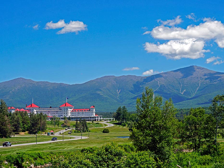
From Franconia, take Rte 93 South to exit 36 to Route 141, turn left, follow to a T, turn left to Route 3 North. This is the White Mountain Trail and leads to the town of Twin Mountain with its beautiful views of the Presidential Mountain Range. Take a right at the lights onto Route 302 that passes the Bretton Woods Ski Area, the base Station of the Cog Railroad at Fabians, and the famous Mount Washington Hotel. Route 302 climbs to the top of Crawford Notch, the location of the Appalachian Mountain Club (AMC) headquarters and the final destination train depot of the scenic railroad train from Conway. As you pass AMC’s Highland Lodge, Saco Lake is on the left (the source of the Saco River), then Elephant Head. As you head down from the notch, there are two cascading, sparkling waterfalls on your left. Further on is the Willey House and welcome center. There are numerous hiking trails off Route 302 through Crawford Notch before it ends at North Conway. North on Route 16 will take you to Storyland, Santa’s Village and Glen Ellis falls. South on Route 16 will bring you to Conway and the entrance to the Kancamagus Highway East to West back to Lincoln. At Lincoln, go right to I-93 North and head to Franconia Notch- where the word notch was first coined and became the colloquial name for all of New Hampshire’s five mountain passes to get North, South, East and West of the great White Mountains. The sheer cliffs and mountain peaks in this narrow pass formed a familiar “V” from every angle, reminding early settlers of the notches they chinked out of the logs for fitting them together to build their cabins and homes. These pathways, or passes, through the mountains were soon referred to as ‘notches”, each picking up family names or names of familiar places to complete their identities. Franconia Notch is the most awe inspiring and beautiful notch of the five because of the narrowness, eight-mile length from Cannon Mt. to the Flume Gorge, challenging ski slopes that seem to end in Profile or Echo Lakes and the roadway, but mostly – for it’s glacial rock formations- the Old Man of the Mountain, the Cannon Balls and Cannon, the Old Lady, the Dog, the Basin, Boise Rock and the Flume Gorge- all carved and created over ice age glaciations between 50,000 and 10,000 years ago. Mt. Liberty, Little Haystack,Lincoln, & Mt. Lafayette make up the Franconia Ridge on one side, Kinsman Ridge, home to Mt. Kinsman, the Cannon Balls and Cannon Mt. on the other, form the tight “V” notch as six of these are over 4000 feet in height. Follow I-93 North to Exits 37 and 38 bring you back to the village of Franconia.
In Franconia, drive straight across Main Street at Exit 38. You will be on Route 116; drive South through Easton and enjoy the Kinsman Range on your left. At the intersection of Route 112, turn left toward Woodstock (North Woodstock) The road will take you through the pass of Kinsman Notch, with Mt. Kinsman on your left and Mt. Moosilauke on your right to the back. After Lost River, turn right (South) on to Route 118. You are driving on the East side of Mt. Moosilauke. Half-way up is a look out on the left side with a beautiful view of the Franconia Ridge and the town of Lincoln. Onward, the road follows delightful S turns and starts to descend following the Baker River. Route 118 comes to Route 25. Turn right and follow 25 Northwest through Glencliff, Pike and North Haverhill- hikers can pick up the Appalachian Trail at Mt. Moosilauke from Glencliff. Route 25 ends in North Haverhill on the Western side of NH turning to route 10. Turn right into 10 traveling North following the Connecticut River Valley and joins Route 302 in Woodsville. Take 302 Northeast to Bath, the most scenic stops of covered bridges and waterfalls next to the Bath General Store, (the Brick Store) that dates back to 1790. beside the covered bridge. Staying on 302 will take you up through Lisbon where you can connect to Route 117 on your right after the “straight line”, bringing you over Sugar Hill to enjoy the panoramic view of the Presidential Range driving East to the top of Franconia village. The backward loop of Routes of 112 to 116 to Franconia is a right turn just before Bath village from 302 at Woodsville.
Less populated, with many opportunities to see wildlife including moose, black bear and deer, this section of New Hampshire is a must-see for nature lovers. Driving South on I-93 from Franconia, take exit 36, turn left onto Route 141. At the T turn left on Route 3 North to Twin Mountain. Go straight through the lights at Twin Mt. to Lancaster. Staying on route 3, you will pass through the towns of Lancaster, Northumberland, Groveton, North Stratford, to Colebrook, following the Connecticut River with great views of Northern Vermont on the other side. In Colebrook, turn right to Route 26 and a short drive across this narrow part of New Hampshire to Lake Umbagog which is shared with the state of Maine; a wildlife and sporting wilderness haven. Half way there, you will drive through Dixville Notch, the most Northern of the five New Hampshire Notches, famous for its cragginess and northern exposures. As you enter Dixville Notch, the Balsam’s Resort is on the left. Standing grand against magnificent peaks and an endless span of breathless views in every direction, this resort is a luxurious experience for those who want to spend entire days challenging the wilderness of all four seasons whether its on the golf course, ski slopes, snowmobiling, hiking, wild game hunting or fishing. Be prepared to meet seasonal sportsman and plenty of New Hampshire Moose plates. Before Lake Umbagog at Errol, turn right to Route 16 following the Androscoggin River South to Milan, turn right to Route 110B, or just follow the signs to Milan Hill State Park. Passing through the park, Route 110B joins 110A. Turn left to West Milan, join Route 110 and travel East to historic Stark of World War II fame as a concentration camp for German soldiers put to work in the Great North Woods, but more so for its covered bridge and ancestral cemetery on a layered hillside that looms on the left of the road facing the small area of four churches and buildings exemplifying the ruggedness of the early settlers of the Northern wilderness of NH. You will drive through the tip of the White Mountain National Forest on your left and the Nash Stream Forest on the right. Route 110 leads from Stark to Groveton and joins Route 302 South. Left on 302 will bring you back to Lancaster, Whitefield, and Twin Mountain to Franconia with its variation of views driving South and completing the loop.
There are options on this drive at Milan on Route 16. Continue South on 16 along the Androscoggin River to Berlin- “The City that Trees Built”, and home of the Northern Forest Heritage Park. Driving on to Gorham, there are reminders of the logging days of the past with its legacies and heritage along the Androscoggin. Turn right at Route 2 toward Jefferson along the North side of the Presidential Range. There are three choices here that make these loops grand vistas of the top of the White Mountain National Forest with many stops for hiking, sporting and wonderful North Country lore if you stop for refreshing pauses along the way. (A) Continue on Route 2 to Lancaster, turn West to Route 135 toward Lunenburg, Vermont, which turns South to Dalton, NH. Connect to Route 142 before Dalton and follow the Route signs through Whitefield to Bethlehem into Franconia on a true country scenic “back roads” tour. Route 142 ends in Franconia on Route 18, 1/2 mile from the Welcome Center on Main Street. (B) At Jefferson from Route 2, turn left on Route 116 to Whitefield, pick up Route 3 North to Lancaster to catch the scenic view from Morrison Hill past Weeks State Park. At Lancaster, take Route 135 along the Connecticut River to Littleton. Jump on to I-93 South, which is a New Hampshire Scenic by-way around Littleton bringing you to Exit 38, Main Street Franconia. This seven mile drive provides magnificent views of Mt. Lafayette and Cannon Mt. from the North driving South leading right into Franconia Notch State Park. (C) At Jefferson, turn South on 115A that connects to Route 115 on the right, winding West and South to Twin Mountain past Cherry Mt. and Mt. Martha, well known for hiking trails and vistas from Jefferson Heights. Turn west onto Route 302 at Twin Mountain for a scenic drive through Bethlehem and it’s hospitality lined Main Street past two golf courses renowned for mountain views on your right. Leaving Bethlehem, turn onto Profile Road past Profile High School complex. This will connect to Route 18 at the end. Turn left toward the village of Franconia, a 3/4 mile view of Franconia Notch coming from the Northwest with opening views of Sugar Hill on the right and a different angle at the top of the Notch straight ahead.