THINGS TO DO > GREAT OUTDOORS
Hiking
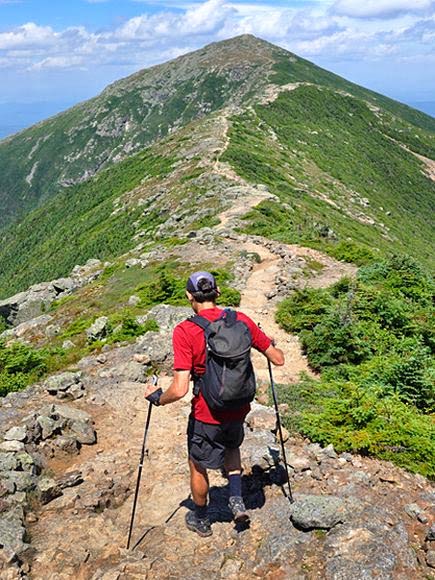
The White Mountains of New Hampshire is a hiker’s paradise. This region of northern New England attracts tens of thousands of hikers every year. The Presidential Range offers hundreds of miles of remote trails, mountain tops and scenic splendor.
Below you will find just a sampling of the dozens of hiking trails available to hikers of all levels of experience and expertise.
Steeped in more than 100 years of tradition, the AMC’s network of mountain huts provides a unique backcountry adventure for novice and experienced hikers alike. Each hut is a day’s hike apart along the Appalachian Trail in New Hampshire’s White Mountains.
AMC Huts offer mountain hospitality in spectacular locations above treeline or near mountain lakes or waterfalls.
Resources:
White Mountain Lodging – New Hampshire Appalachian Mountain Club
Lonesome Lake AMC Hut – Franconia Notch State Park
A great destination for families, AMC Huts offer a range of “big mountain” adventures and activities for kids of all ages, whether it’s your child’s first hike or a summer challenge for your teen.
Hiking Safety
There are many hazards while hiking in these rugged mountains: slippery rocks and roots, difficult stream crossings and open ledges. We want you to be safe on the trails! The NH Fish and Game Department and the White Mountain National Forest are partners in a mountain safety education program called “hikeSafe” to help get the word out on what hikers need to know.
As part of this program, the Hiker Responsibility Code is posted on hikeSafe signs at all major trailheads in New Hampshire. The code applies to all hikers, from beginners on a short hike to experienced outdoor enthusiasts embarking on an expedition. Please practice the elements of the code and share the code with fellow trekkers. This will help increase responsibility and reduce the need for Search and Rescue efforts.
Visit hikesafe.com for helpful information.
Hiking Trails
Easy Trails in the Area
Bald Mountain-Artist Bluff Franconia, NH
Distance: 1.5 miles / Rating: Beginner
Spectacular view of Franconia Notch with minimal effort. Take I-93 north to Exit 34C, take a left on Rte. 18 pass Echo Lake and park on right across from Cannon Mountain. Trail starts in back left corner of Cannon Mountain parking lot. The trail is well traveled and has been recently updated with new signage. View topical map.
Flume-Pool Loop-Franconia Notch (fee charged)
Distance: 2.2 miles / Rating: Beginner
Access this trail from the Flume Gorge Visitor Center, Exit 34A off I-93. Maps and details are provided at the Center.
Fox Hill Park- Franconia
Distance: 1 mile / Rating: Beginner
Beautiful views of nature and the Gale River
Go on Rte. 18 south towards Cannon Mountain. Take first left after intersection of Rte. 116 & Rte. 18, Dow Rd. Go straight across the bridge, Fox Hill Park is on the left about 2 miles. There are two trails; the Scenic Trail and the Gale River Trail.
Franconia Notch Recreation Trail – Franconia Notch State Park
Distance: 9 miles / Rating: Beginner
Beautiful views of the Notch. This 9 mile paved bike path goes through Franconia State Park and passes Echo Lake, the Old Man of the Mountain, the Basin, and the Flume Gorge which are all main attractions of Franconia Notch state Park in the western White Mountains.
This is a multi use trail including snowshoeing, cross country skiing & snowmobiling.
To access the path in the north, the parking lot and bike path starts at the lot on the right just after you enter Rte. 3 north to Twin Mountain at Exit 35 from I-93 north. To start the trail from the south, you can park at the Flume Gorge parking lot at Exit 34A off I-93. Go all the way over to the left and you will see the start. The best way to enjoy this trail is to start at one end and leave your car at the other parking lot, north to south. To do the trail round trip, it is best to start at The Flume parking lot. Bike rental places are available at Exit 34B at the Aerial Tramway Welcome Center. Franconia Notch Trail map
Hiking and Nature Trails
The Rocks Estate
Distance: .8 miles / Rating: Beginner
Route 302 off Exit 40 from I-93, Bethlehem
Walk, hike, snowshoe or cross-country ski the nature trails at Bretzfelder Memorial Park and The Rocks Estate, open year-round and dogs are welcome. No wheeled or motorized vehicles are allowed. See Trail Information for maps. Unforgettable outings can be scheduled for teachers and students at these North Country properties of the the Society for the Protection of New Hampshire Forests. Trail information here.
Kilburn Crag – Littleton
Distance: 1.8 miles / Rating: Beginner
Nice view of the Presidential range and the Town of Littleton. An easy trip to a viewpoint overlooking the town of Littleton and many high peaks. Generally considered an easy route, it takes an average of 56 min to complete. This is a popular trail for hiking and walking, but you can still enjoy some solitude during quieter times of day. The best times to visit this trail are April through October. Dogs are welcome and may be off-leash in some areas. Take Rte. 93 north to Exit 43 and take a right on Rte. 135. At the intersection of Rtes. 18/135 take a left. About a half mile on the left, a sign designates the parking area.
Pemi-Trail – Franconia Notch
Distance: 4 miles one way / Rating: Beginner
Lovely views of the Cannon Cliffs, Profile Lake, The Basin & Pemigewasset River. You can start in 4 places: Old Man Historic Site (Exit 34B) right parking lot, the parking lot south of Profile Lake, Lafayette campground parking Lot, the Basin parking lot, or the Liberty Springs parking area. It roughly parallels the river, the highway and the bike trail.
More Challenging Trails in Area
Bald Peak
Route 116, Easton
Distance: 4.6 miles / Rating: Intermediate
Beautiful view of the Easton valley and Vermont. Take I-93 north to Exit 38. Take a left, go straight at the lights and follow Rte. 116 for 4.4 miles. Trail is on the left beside a green sign marking the Easton/Franconia town lines. There are no trail signs; it starts as a road with 2 stone pillars and a chain entrance. This trip goes to an open ledge jutting out of the side of Kinsman Mountain. At mile 2.1 you will come to the Kinsman Flume Trail (do not take this trail in the winter), stay left. Shortly after, you come to the spur trail to Bald Peak branching off to the right. The Kinsman Trail continues to the left but is for experts only.
Basin-Cascade Trail
Franconia Notch State Park
Distance: 1 mile / Rating: Intermediate
Up close to two different falls, Kinsman & Rocky Glen with a great view of Mount Liberty. Take I-93 north to the Basin between Exit 34A and 34B. Leaving the Basin area, the trail ascends near to Cascade Brook and a beautiful series of cascades leading in a half-mile to Kinsman Falls and on to Rocky Glen Falls. Soon the brook is crossed on a log-bridge and is joined by the Cascade Brook Trail. The trail gets rougher after this on your way to Lonesome Lake.
Cascade Brook Trial
Franconia Notch State Park
Distance- 3.1 miles / Rating: Intermediate
Beautiful views of nature and the Notch. Take I-93 north to Exit 34A. Park at the Flume parking lot and take the Whitehouse Trail for .8 mile to join the Cascade Brook Trail. At 1.5 miles this joins the Basin-Cascade Trail. In another .5 mile, the Kinsman Pond Trail goes to the left. This leads to Lonesome Lake Hut.
Coppermine Trail to Bridal Veil Falls
Route 116, Easton
Distance: 5 miles round trip / Rating: Intermediate
Trail to the beautiful Bridal Falls. Take I-93 north to Exit 38, take a left on to Rte. 116. At blinking lights, go straight, follow Rte. 116 for 3.4 miles. Look for Coppermine Rd. on the left. Trail starts off the road up ahead. Trail follows Coppermine Brook. About 2 miles in, the trail crosses a bridge. Bridal Veil Falls is .2 miles after the bridge.
Falling Waters Trail
Franconia – Notch State Park
Distance: 2.6 miles round trip / Rating: Intermediate
Great hike viewing of 3 waterfalls- Stairs, Swiftwater & Cloudland. Start at Trailhead parking lot on the right on I-93 north between Exits 34A & 34B or park at the Lafayette Campground and cross under the Interstate. This is one of the most popular trails in the area. This trip goes only as far as the ledges, hanging on the edge of the deep ravine of Walker Brook. Going any further is for experts only. At .2 miles, Falling Water Trail goes to the right, Old Bridle Trail goes straight. This trail follows Dry Brook. You will pass 3 waterfalls: Stair Falls, Swiftwater Falls, and Cloudland Falls. Follow the trail to the top of the falls for a beautiful view. Good point to turn around, rest of the trail goes to the very difficult Little Haystack.
Indian Head Trail
Route 3, North Lincoln
Distance: 1.9 miles / Rating: Intermediate
Great Views up the Franconia Ridge and down toward Lincoln. Take I-93 north to Exit 33, Rte. 3 north. The path begins at a parking lot on the left off Rte. 3 and follows an old logging road for the first 1/4 mile through the woods. The trail then heads north, climbing more steeply and passes below the cliffs of the famous “Indian Head”. It is a short From the junction with Mt. Pemi Trail, it is a short distance to the summit.
Lower Georgiana Falls
Route 3, North Lincoln
Distance: 1.6 miles round trip / Rating: Intermediate
Trail to the base of Georgiana Falls. Take Exit 33 off I-93 head north on Rte. 3 for .2 miles, turn left on Hanson Farm Rd. In .2 miles when the main road bends right you go straight to a plowed parking area. Go under the Interstate and follow the signs for Georgiana Falls, a yellow blazed trail that changes to red blazes. Stay close to the brook.
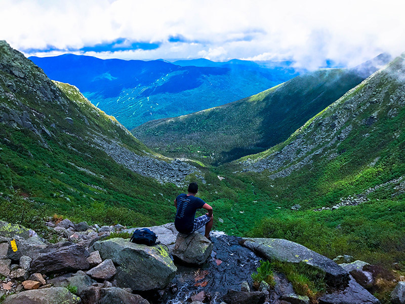
Lonesome Lake
Franconia Notch State Park
Distance: 3.0 miles round trip / Rating: Intermediate
Trail to pristine mountain lake with great views of the Franconia Ridge. Park at Lafayette Campground parking area off I-93 south. Trail starts at the left side of the parking lot. Follow the yellow blazed Lonesome Lake Trail. After a mile, High Cannon Trail splits to the right. Stay on Lonesome Lake Trail, as it now becomes steep. When you get to the top, take the Cascade Brook Trail along the south side of the lake.
Mount Pemigewasset Trail
Franconia Notch State Park
Distance: 3.6 miles round trip / Rating: Intermediate
Great Views up the Franconia Ridge and down towards Lincoln. Start at the Flume parking lot (Exit 34A off I-93) left side. Follow bike path until you find the sign for the Mount Pemi Trail on the left. Follow the blue blazed trail. This is a ledge with beautiful views. This is a major drop off so be very careful of your footing.
Old Bridle Path
Franconia Notch State Park
Distance: 4 miles round trip / Rating: Intermediate
Great views of the Notch. Start at Trailhead parking lot on the right on I-93 north between Exits 34A & 34B, or park at the Lafayette Campground and cross under the Interstate. This is one of the most popular trails in the area. At .2 miles the Falling Water Trail goes to the right; the Old Bridle Trail goes straight. At 1.9 miles you will emerge on the first of two spectacular open ledges. The next is 100 feet further. This might be a good place to turn around since the rest of the trip up Agony Ridge to the Greenleaf hut is very difficult.
Most Difficult Trails in the Area
Appalachian Trail
The AT passes thru Franconia Notch as it winds its 2100 mile way from Georgia to Maine. It coincides with segments of the Kinsman Ridge, Fishin’ Jimmy, Cascade Brook, Liberty Springs, Franconia Ridge and Garfield Ridge Trails. The distance from Gordon Pond Trail to Mt. Garfield is 23 miles.
Fishin’ Jimmy Trail
Distance: 2.0 miles / Time: 1 hour 40 minutes
This path has some rough footing and steep ascents. It connects the Lonesome Lake Hut with Kinsman Pond Shelter.
Flume Slide Trail
Distance: 3.3 miles / Time: 3 hours / Elevation gain 2700′
The path departs from Liberty Spring Trail 0.6 mi. from its start at Whitehouse Tr. The first mile ascends moderately, then steepens, finally becoming very steep, wet and dangerous. Watch for loose rocks on the slide. Avoid descent of the trail, especially with heavy packs. There are excellent views at the top near the summit of Mt Flume.
Green Leaf Trail
Distance: 3.8 miles / Time: 3 hours 40 minutes / Elevation gain 2200′
This trail climbs steeply out of the Notch to Greenleaf Hut, with occasional views. Beyond here the route is exposed to storms on Mt. Lafayette. Eagle Pass is reached in 1.5 mi./ 1 hr. 20 min; Greenleaf Hut, 2.7 mi./ 2 hr. 30 min; Mt Lafayette, 3.8 mi./ 3 hr. 40 min.
High Cannon Trail
Distance: 2 miles / Time: 2 hours
The trail leaves the Lonesome Lake Trail 0.4 mi. from Lafayette Campground and climbs steeply up the south side of Cannon Mountain. The Dodge Cut-Off joins it at 0.8 mi. There are many outlooks over the lake and Notch beyond here, but the path is rugged and uses a ladder at Cliff House rock. From its end at the Kinsman Ridge Trail, it is 0.4 mi./ 20 min. to the summit.
Distance: 2.5 miles / Time: 2 hours / Elevation gain 1300″
This rough, wild and very beautiful trail leaves the Cascade Brook Trail (2 mi from its start), soon crosses the brook and enters lush forests. The trail is wet in many places and climbs steadily; Kinsman Pond is reached at 2.1 miles.
Distance: 17 miles / Time: 12 hours
This trail traverses the entire western half of the Notch passing over several peaks; much of it is part of the Appalachian Trail. Beginning at the tramway parking lot in the Notch, Kinsman Ridge Trail climbs steeply 2000′ up Cannon Mountain. There is a side path at 1.5 mi. leading to excellent views down into the Notch and across Franconia Ridge. Further along its length are fine views from the summits of the two Kinsmen’s and Mt. Wolf.
Liberty Springs Trail
Distance: 3 miles / Time 3 hours / Elevation gain 2700′
From the Whitehouse Trail, 0.8 mi. north of the Flume parking area, the Liberty Spring Trail climbs east as part of the Appalachian Trail to join the Franconia Ridge Trail near the summit of Mt. Liberty. Distances: Flume Slide Trail- 0.5 mi./ 35 min.; Stream crossing- 1.1 mi./ 55 min; Liberty Spring Tent Site- 2.6 mi./2 hr. 35 min.; summit of Mt. Liberty- 3.2 mi./ 3 hr.
Mt. Kinsman Trail
Distance 3.7 miles / Time: 3 hours 20 minutes / Elevation gain 2800′
Trail leaves Rte. 116 about 4 miles south of Franconia and follows a logging road for the first mile or so. At 2.1 mi./ 1 hr. 50 min. from the start, a side path leads west 0.2 mi. to fine views from Bald Peak. The next 1.5 mi. are moderate, with a few steep scrambles, before Kinsman Ridge Trail is reached 0.2 mi. from Kinsman Jct.
Old Bridle Path
Distance: 3 miles / Time: 2 hours 45 minutes / Elevation gain 2400′
The trails leaves from the Lafayette Place parking lot on the Interstate, heads east, then north up “Agony Ridge” to Greenleaf Hut.
Skookumchuck Trail
Distance: 4.4 miles / Time: 3 hours 45 minutes / Elevation gain 2800′
From the parking area on Rte. 3 at the north end of the Bike Path, this trail climbs thru the woods to the Garfield Ridge Trail, 0.7 mi./ 45 min. north of Mt. Lafayette.